Putrajaya Wetlands is a 200 hectares area with a vegetated horizontal surface flow multi-cell wetland system, with different water levels in each of its 23 cells.
Map of the Putrajaya Wetlands.
It has one of the more challenging gravel bike trails in Putrajaya. It is suitable for an intermediate rider due to its challenges, not suitable for a new rider. You need a mountain bike with front suspension and knobbly tyres. Helmet and gloves must be worn while riding on this trail.
The place to park your cars, and to begin your bike ride is at;
Pusat Rekreasi Air,
Putrajaya Wetlands
Exit Persiaran Utara
Presint 1
62000 Putrajaya
Wilayah Persekutuan Putrajaya,
Malaysia (GPS N2.952017° E101.699010°)
Those coming from the north via SKVE may have to circle around the PERSIARAN SULTAN SALAHUDDIN ABDUL AZIZ SHAH to get to the recreation centre as illustrated below.
How to get to the starting point.
Be careful here, you don't want to miss the turn.
This is the bike route of Putrajaya Wetlands.
My two kids on their MTBs, front suspension, complete with helmet and gloves. Don't forget your water bottles!
One of the many scenic bridges with the ducks in the lake.
A closer view of the ducks.
I really can't remember why I took this photo.
Look at the right side, that black object is a small weir for treating the water.
A broad-crested weir, separating the many cells of the lake.
That marshy area is not for walking, it is part of the cells for water treatment.
Again another cell with a different type of reeds to help treat the water.
At the right angle, the water reflects the image of the plants.
At this cell, you have tall trees by the lakeside. One of the more beautiful view, yet unseen by others.
No water plants here. Maybe because this is where Sungai Bisa joins the lake.
No water plants here. Maybe because this is where Sungai Bisa joins the wetlands.
Where Sungai Bisa really join the wetlands. The trail is flooded and not rideable. Time to turn back.
Map showing where we turned back due to flooded bike trail.
For those young at heart, you can emulate Che Mohd Adib cycling through the flooded section.
After backtracking some distance, we found a safe broad-crested weir to cross the lake.
These trees were on the other side of the lake.
My two exhausted kids. Must be glad to be near the finishing line. This is one of the safer crossing that you could ride through if you don't want to ride to the end of the "left horn of lake". The route would be much shorter though.
Take note that at the south end of the trail, you have to get on the road & cycle across the bridge before reaching the starting point.
Expect to spend up to two hours cycling this totally flat 15 km trail. Make sure that your bike is suitable for off-trail riding and bring enough water. You may want to bring some energy bars with you.
I just realised that although this blog is about cyclists in Putrajaya, we hardly post about the scenic routes available in Putrajaya, especially routes suitable for family rides. Allow me to rectify that with an easy, totally flat, scenic 11 km route around the Putrajaya's Core Island which is quite safe, and isolated from the road traffic.
This is a screen capture of my ride today with my two teenage children. I believe you would immediately understand what I meant with the phrase "Core Island" after looking at the image. The route follows the lakeside jogging/cycling path around the core island.
You can start any where along this route but my favourite starting point is the parking area (N2.92193 E101.68289) near the Umai Cafe, between the Iron Mosque and the Millennium Tower. Best to start right after sunrise around 7.30 am so that it would not be too hot for your kids. Once you are ready, just head towards the Millennium Tower, so that you would be circling the island clockwise. Most of the cyclists ride clockwise, so it is better to follow suit. By going clockwise, there would be less issue of taking blind corners or getting stuck at a dead-end after missing a critical turn (such as the one near Jalan P18D).
1. The first significant building that you would see on this route would be the Millennium Tower. It is uniquely shaped like an obelisk with etchings denoting important periods and milestones in the nation’s history. The monument is 68 metres tall.
2. The second significant building along this route is a bridge, the Seri Wawasan Bridge. This futuristic cable-stayed bridge which has a sail ship appearance, connects Precinct 2 on the Core Island to the residential area of Precinct 8.
It also looks like Rama VIII bridge in Thailand or Golden Gate Bridge, or any other cable-stayed bridge in the world, for that matter. But the sail ship appearance is unique for the Seri Wawasan Bridge. In fact, the bridge reminded me of the BURJ AL ARAB JUMEIRAH building in Dubai.
3. The next significant building along this route is the "Pink Mosque" or Masjid Putra. It was completed in 1999 and it is the principal mosque of Putrajaya, Malaysia. It's dome was inspired by the Sheikh Omar Mosque in Baghdad. Their dome has blue tiles, ours has pink tiles. Hmmm .... male and female version?
4. Right beside the Putra Mosque is the Putra Bridge. The bridge design was inspired by the 17th century Khaju Bridge in Isfahan, Iran. With a span of 435 metres, this Putra bridge connects the Government Precinct to the Mixed Development Precinct and links Putra Square with the Boulevard. It was constructed in 1997.
4. After this bridge, you would be entering the beautiful Taman Wawasan. It used to be even more beautiful in 2008 but some of the water features such as the lotus pool is no longer there.
But it is still worth a visit.
The park ends at Seri Bestari Bridge, is a large arch bridge connecting Precinct 16 and Wisma Putra on Core Island. The bridge has a total length of 152.6 meters with a main span of 60 meters.
5. After the Seri Bestari Bridge, you would be entering the Precinct 18 residential area. You would be cycling behind these exclusive homes. Once the residential area ends, you would see Seri Setia Bridge, which provides a vital link between Precinct 19 and the Commercial Precinct and the main route to the core island from the southeast. The bridge is made up of eight equal spans of 30 metres each, it also has lancet-arch designs on its railing that complement the fascia panels on its side.
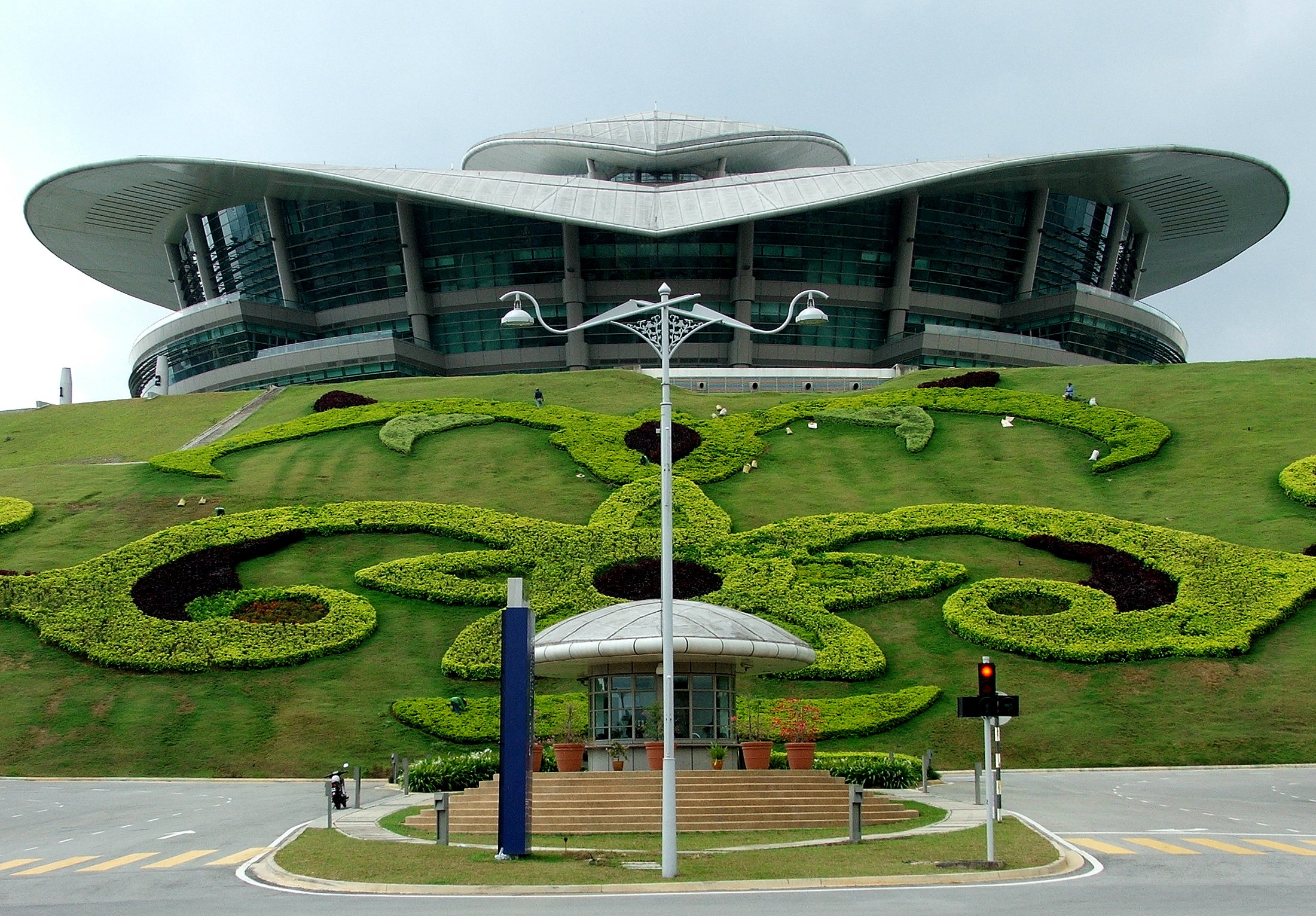
6. After the Seri Setia bridge, you would be passing the many government towering complexes in Heritage Square. If you look across the lake, you would be able to see the "Forbidden Bridge", which is part of the dam wall which created the artificial lakes of Putrajaya. It is because these man-made lakes, that all these bridges becomes a necessity. At the end of the dam wall, you can see the Putrajaya International Convention Centre (PICC), towering over Putrajaya from it's highest vantage point. Then you will see the Seri Gemilang Bridge, a ceremonial bridge which connects the Heritage Square with Putrajaya Convention Centre. The bridge has a main span 120 metres (394 ft) long, with a 60-metre (197 ft) span at each end, for a total length of 240 metres (787 ft). There are six traffic lanes, each 3.5 metres (11.5 ft) wide. The deck level above the water is 36.75 metres (121 ft) at the centre of the bridge. It is supposed to resemble Pont Alexandre III, a deck arch bridge that spans the Seine in Paris.
7. After admiring the beautiful Seri Gemilang bridge, time to press on north towards Seri Saujana bridge. The bridge's design is unique cable-stayed arch bridge and it is similar to the Sydney Harbour Bridge in Sydney, New South Wales, Australia. Seri Saujana bridge links the core island towards Cyberjaya and the ELITE Highway.
Right beside the beautiful bridge however is an unfinished bridge, which is suppose to be part of the monorail servicing Putrajaya. Sad.
8. The last but not the least significant building along this route is the "Iron Mosque" or Masjid Sultan Al-Mizan. When it was a "sick project", it was an eyesore along this route. Now it is a beautiful addition to the route.
Just a few hundred metres ahead is where you have parked your car. After enjoying the ride, now you can put away your bikes and enjoy a nice breakfast at the nearby cafe. Ride Safe!
One of my favourite cycling route is to cycle from Semenyih Sentral (bus station) to LEKAS (Lebuhraya Kajang-Seremban) Highway until the Mantin exit. From there we will exit the highway and cycle over Bukit Puyoh and head on to Lenggeng, Broga and back to Semenyih Sentral. A distance of 55km.
Since 13 Feb 2010 (but only officially opened since 1st March 2010), the Setul and Ampangan Interchange of LEKAS was open for traffic. Therefore now the entire stretch of the 44.3km Kajang-Seremban Highway (Lekas) was open to traffic. Now we can increase the cycling distance.
Dr Ahmad Taufik Jamil invited a few of us to ride the new stretch of LEKAS Highway on Sunday 7th March 2010. So four of us (myself, A Taufik Jamil, Tzyya Won and Mohd Farris Mat Nawi) turned up at 7.30 am at Petronas Prima Saujana. We planned to ride from Saujana Prima to Ampangan, turn back to Mantin exit, cycle over Bukit Puyoh and head on to Lenggeng, Broga and back to Saujana Prima. A distance of 105km.
We started at 7.38 am from Saujana Prima. Starting from Saujana Prima is a bit tough for me since there were 5 climbs before reaching the LEKAS Kajang Selatan toll booth. Being an obese person, I was left far behind. Once we start cycling on LEKAS highway, the going gets easier since it was relatively flat until Mantin exit.
Vertical profile of the route until Ampangan exit.
After that the going gets tough since there was a vertical ascent of 140m in 7km distance. Farris kept me company for most of the climb to the top. It was a tough climb but do-able. I didn't push to the max since I know that I have a long way to go. My heart rate during the climb was only around 160 bpm.
Red line = heart rate in bpm, blue line = speed in km/hr, dark brown line = altitude in metres.
After the tough climb, it was an amazing downhill ride. Despite pressing on the brakes, I was hitting 56 km/hr. You don't want to make any mistake at this speed on a road bike, otherwise you'll be kissing the asphalt and end up with an amazing road rash to display instead. The only "speed bump" was the Setul toll booth, halfway down the hill. We had to slow down to navigate the narrow cyclist lane at the toll booth.
We had two choices, to exit at Sikamat or Ampangan. We chosed to exit at Ampangan since we were hoping to find a food stall. It was already 10 am and we were hungry after cycling 46km. The Ampangan exit brought us to Kuala Klawang road, which led to Jelebu via the Bukit Tangga road. We turned to Panchor Jaya and had roti canai at Teratak Restu Ibunda foodstall.
Map to Teratak Restu Ibunda food stall
After a good rest, we started our ride back. Since there were many hills to climb on the way back to Mantin exit, once again I was left far behind. They waited for me at the Sikamat exit, just before the long steep uphill climb to the Setul toll booth. Farris again waited for me at the Setul toll booth just to make sure I make it up the hill.
Coming down the hill towards the Mantin exit would had been fun, if not due to the strong crosswind. I was having difficulty keeping my bike upright and straight due to the strong crosswind.
Due to the hot weather, riding on the LEKAS highway under the hot afternoon sun was not an option anymore. We already ran out of water so we got off the highway at the Mantin exit and headed towards the nearest 7-11 in Mantin town. After refilling our water bottles, we rode on towards Beranang. To escape the hot afternoon sun, we took a detour into Kg Jalan 6 Kaki and came out at Jalan Bangi Lama. We headed towards Semenyih and reentered LEKAS highway via the Semenyih interchange. We rested at the R&R at LEKAS Semenyih toll before tackling the final hill climbs before Prima Saujana.
By the time we reached Prima Saujana, it was already late. We ended up cycling 103 km in 04:52:53 hours with an average speed of 21.10 km/h from Saujana Prima to Ampangan and back via LEKAS .
To Dr A Taufik Jamil, Tzyya Won and Faris, thank you guys for your patience :-)
After suffering under the hot sun, instead of using this route, I would like to suggest another option.
Instead of cycling to & fro on the same route, it would be nicer to cycle in a loop. It would be better to ride on the highway in the morning when it is cool and turn back using the old trunk road since it would be shaded and easier to find stalls for food and to stock up on drinks.
One route suggestion which has already been tried out by Pak Wan and the Gedebe group is to start from Semenyih Sentral, get on the LEKAS highway and ride to Ampangan. Then take the Kuala Klawang road towards Pantai and Pajam. Can have a meal break at Pantai. At Pajam turn left, go over Bukit Mandom to reach Lenggeng. Another meal break here. Then a leisurely ride to Broga and back to Semenyih Sentral. Only 90km.
Alternative route, return via Lenggeng, only 90 km.
If I go cycling, I can't involve my entire family since not all can go cycling long distance. At most I can only bring my eldest son, who is already 16 years old. So if I want to involve my entire family in the activity, I have to find something that everyone can participate in.
So instead of going cycling at GCE today with the Rubbermen, I brought my entire family to go trail hiking at FRIM Kepong. Since I was not sure what they could participate in, I brought them to the Salleh Nature Trail behind the FRIM museum. The trail looks dilapidated and not well utilised. In fact my missus missed the trail head totally due to it. The trail was simple enough and not too challenging. Even my 9 year old daughter could cope with it. It took us 35 minutes to complete the 2.2km trail. It was pleasant trail with a variety of plants which could be seen up close. We only encountered another Chinese couple on this trail.
The nature trail ended at the beginning of Rover's Trail. Rover's Trail is a gravel trail, wide enough for a Land Rover to drive on with ease. That's why they call it Rover's Trail since it is meant for a Land Rover aka Rover. This trail was crowded with people, heading in both direction. We continued to climb leisurely upward on this trail for 20 minutes, covering 1.2km in distance and 50 meters in altitude until we reach an open area.
This is where those interested in the Canopy Walk have to make a detour upward using a small and difficult jungle trail. How difficult is it? Very difficult indeed. They should limit this trail only for those between thirteen and fifty years old and properly attired in outdoor gear. My eleven years old son's shoes sole came off half-way during the tough uphill trek and it made his trekking very miserable indeed. Although they claimed that it is only 500 meters from Rover's Trail to the canopy walk, it is really 936 meters in distance and 70 meters in upward altitude. The hike up the canopy walk may be strenuous to many; it is an uphill hike all of the way.
By right, those who wants to walk on the Canopy Walk must buy the tickets from the FRIM Information Centre, near the start of the Rover's Trail. It is RM5 for adults, RM3 for school children and RM1 for small kids. Since the trail is quite tough, I suggest that you leave the small kids behind. If you still want to check it out, bring along water and dress appropriately; light cool clothing is recommended as it gets very hot and humid in the jungle, and good walking shoes or hiking boots is a definite must.
The canopy walkway was built in 1992 on the hillside and spans for about 200 meters. The entire walkway consists of 4 bridges suspended from tree to tree by an elaborate array of ropes. The walkways are just planks hardly a foot wide placed on aluminium ladders supported by the ropes. These 4 bridges are connected by 3 platforms as high as 30 meters from the ground. The middle section is the longest and not for those scared of heights.
My youngest daughter can't get over her fears after almost reaching the middle section and we had to turn back. We walked instead using the jungle trail for 800 meters to the end station of the Canopy Walk, where her mother, elder sister and two elder brothers were already waiting for her. Those who went on the Canopy Walk really enjoyed it in spite of the frightening height. We walked downwards for 620 meters to reach the Rover's Trail again. There is a nice waterfall here.
I asked one of the staff, one Encik Rahim who was on a bike, which way is the best way to go down. He suggested using the "short cut" alongside the waterfall which will take only "10 minutes". Foolishly I believed him. The short cut is really a 1.2 km downward trek and 60 meters in altitude with plenty of obstacles. It took us 20 minutes to reach the bottom of the waterfall.
Luckily there were food stalls here, where we could sit down and recover. I should have used the Rover's Trail instead since that trail is a lot easier and I would've ended up nearer to my vehicle.
I hitched a ride with one of the stall owners to pick up my vehicle since my family were too tired to continue the trek. Maybe they were tired but they enjoyed it very much. We covered 7.2km on foot in 2 hours 12 minutes. Apparently I used up more calories on this hike than cycling 27 km!
PCM - Putrajaya Critical Mass PMR - Putrajaya Morning Ride PNR - Putrajaya Night Ride PER - Putrajaya Evening Ride PAR - Putrajaya Away Ride OOP - Out Of Putrajaya


.jpg&container=blogger&gadget=a&rewriteMime=image%2F*)


